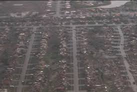
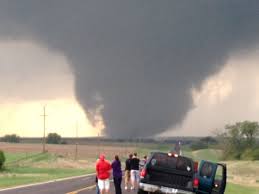
(UPDATED Monday, 20 May 2013) The article below was written 24 hours ago on Sunday when the first phalanx of tornadoes passed through the state of Oklahoma hitting Shawnee, a suburb north of the metropolitan Oklahoma City area. After drawing to my readers’ attention forecasts anticipating a new and deadly tornado season for 2013 I documented six weeks earlier, I felt concerned that what I presented below was too intense. That I was, I at least hoped, exaggerating the onset of a late tornado season that would either match or be more dreadful and deadly than the historic 2011 tornado season. I walked out of my office this afternoon, turned on the Weather Channel and saw reality had become science fiction just 90 minutes earlier. On the screen was the aftermath of a vast wedge tornado. The videos broadcasted of it made it look like it came out of the climate change disaster movie The Day After Tomorrow. (Also check out this article: Climate Change.)
It reached its greatest size as it came right over the heavily populated town of Moore, a southern suburb of Oklahoma City. The flattened rows of neighborhoods scourged by devil winds down to the bedrock bones of foundations, the mountains of cars piled like sand dunes of twisted metal laid against a hospital, the collapsed theaters and the elementary school full up of students in lock down, now just a heap–a Hiroshima wind blasted wreck… It was worse, if that is possible to imagine, than the devastation of Joplin Missouri, the city cut in half and cut down by an EF5 tornado in the 2011 season, killing several hundred. The Moore tornado cut a swath 1.5 miles wide with an outside wind wall cast before it knocking flattening a city in a wave of structure splintering force another mile from its epicenter. Some Doppler wind reports had the twister clocking 200 to 215 mph. This will be designated as an EF5 tornado, I am deadly sure of it. If you have not read this article posted yesterday forecasting what is just the beginning of this fatal season of twisters, please do, especially if you are in places that could be next in line for harm’s way:
***
Friends,
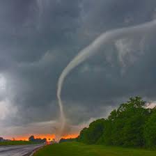
On 30 March 2013, I gave a reader, an American farmer named Ted, some weather forecasts that will appear in my forthcoming eBook Predictions for 2013 and Beyond. I wrote Ted when winter had a tenacious hold on the US central plains, the Great Lakes and north Atlantic seaboard states.Today, I am sharing these documented observations on the worst week of tornado disasters in 2013. The twisters came spinning on 15 May in north Texas outside of the Fort Worth/Dallas area. At least 10-to-16 tornadoes were reported, three of which were a couple of EF3 and one 4 magnitudes, spinning at 150 to 200 mph respectively. These unleashed a house and town splintering intensity leaving many a foundation bereft of a standing structure, killing six and injuring over 100.
On Friday, Saturday to today, Sunday, tornadoes and thunderstorms hurled their twisters and golf ball and softball sized hail fury across the high plains in Western Oklahoma, Kansas and Nebraska then up into Iowa, Illinois and Wisconsin. Up until recently, the jet stream had remained far south, nestling along the Gulf Coast for most of March and April into May, keeping tornado season quiet. Then the air currents of a bothered climate suddenly swung northward, drawing hot and humid subtropical Gulf moisture over the plains states to collide with Arctic air, the collision of such foments violent weather. On Sunday the Weather Channel correctly forecast the highest Torqon levels of the year anticipating the chance of seven tornadoes in a radius of 50 miles across the eastern portions of Kansas and Oklahoma and the Midwestern states affecting 25 million people. Twenty-four tornadoes and counting passed through these areas on Sunday. Monday will place the same areas under tornado threat of a Torqon of five.
Here is my tornado season forecast of 2013 sent to Ted on 30 March 2013:
Notice how the pattern of this year is similar to that of 2011, only more intense. Remember how 2011 had one snow breaker blizzard after another? Then a shift. Then April came.
Suddenly there was a dramatic change. The winter storms stopped and were replaced with an April tornado season the likes of which was for the record books in deadliness.
So, be mindful in the latter days of mid to late April for tornadic events to be as bad if not worse than 2011 mostly running again through the US southern States but be mindful of eastern Kansas.
Now, things [the drought] will soften in May but be mindful of the move of the jet stream to a higher latitude this year, again, just like what happened in 2011. This means some New England violent tornadic weather again and such lingering through the Illinois, Indiana, and Minnesotan regions.
I hope that helps with your planting needs.
Keep reading:


No comments:
Post a Comment
Note: only a member of this blog may post a comment.